
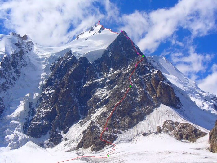
2nd highest mountain in the world. The highest mountains in the world: Seven Peaks
As you know, there are 6 continents on planet Earth, each of them has its own highest point. 7 peaks of the world- these are the peaks of six continents, the largest of them, Eurasia, has two peaks: Europe and Asia.
We offer you a list of seven peaks in ascending height. The easiest mountains to climb, which do not require special mountaineering training: Kosciuszko and Kilimanjaro.
The “7 Summits of the World” program appeared thanks to the American Dick Bass: in 1981, together with Frank Wells, he embarked on an ambitious project, deciding to conquer the highest points of the continents. Starting from Mount McKinley, Bass had summited all 7 peaks by 1985. Now the “7 Peaks Club” unites thousands of followers around the world.
In addition to the seven peaks of the world, there are the highest mountain peaks on the planet, exceeding 8000 meters above sea level. In total, there are 14 eight-thousand-meter mountains on Earth, all of them are located in Central Asia. In addition to Everest, these include: Chogori, Annapurna, Makalu, Cho Oyu, Dhaulagiri, Manaslu and others.
It is difficult even for experienced professional climbers to get the “crown of the earth,” that is, to conquer all the available eight-thousanders; the “seven peaks of the world” program is more accessible.
7 peaks: list
There are two versions of the Seven Summits of the World program, the duality being associated with the continent of Australia. Its highest point is Kosciuszko Peak, but in New Guinea, which formally belongs to Oceania, there is a higher point - the Carstens Pyramid or otherwise Mount Jaya. Based on the fact that Australia and Oceania are one part of the world, the ascent should be made to Mount Jaya. Climbers choose the most convenient option for them or conquer two points at once.
There are also sometimes discussions about Elbrus: should we consider this peak located in Europe or Asia? Those who adhere to the second version consider Mont Blanc, located in the Western Alps, to be the highest peak in Europe. Thus, excluding Elbrus from the program of 7 peaks of the world, since the highest peak in Asia is Everest (Chomolungma).
Kosciuszko

Part of the world: Australia
Mountain system: Australian Alps
2228 meters
First ascent: in 1840
The first conquerors: Pavel Edmund Strzelecki
The lowest of the world's seven peaks is Mount Kosciuszko, it rises in the territory national park"Kosciuszko" in Australia. Polish traveler Edmund Strzelecki was the first to climb the mountain in 1840. He also came up with the idea for the name of the peak: in honor of the national hero of Poland Tadeusz Kosciuszko (1746 - 1817).
 Stone pedestal on Kosciuszko Peak
 Climbing Kosciuszko is accessible to unprepared tourists; this is facilitated by the low altitude and convenient trail - it is impossible to get lost here. A walk to Kosciuszko can be combined with the second highest peak in Australia - Townsend (2209 meters).
Jaya or

Part of the world: Australia and Oceania
Mountain system: Maoke
Summit height above sea level: 4884 meters
First ascent: 1962
The first conquerors: Austrian climbers B. Huizinga, R. Kippax, F. Temple under the leadership of Heinrich Harrer.
Mount Puncak-Jai or simply Jaya (Victory), another name is the Carstens Pyramid, located on the island New Guinea on the territory of Oceania. It was discovered for Europeans by Jan Carstens in 1623, for which it received its name.
The Carstens Pyramid is considered technically quite difficult to climb; you will need climbing equipment. There are two options for climbing Mount Jaya: by helicopter to the base camp, or on foot through the jungle. The first method is faster and safer.

Part of the world: Antarctica
Mountain system: Elsworth
Height above sea level: 4892 meters
The first conquerors: a group of 10 American climbers led by Nicholas Clinch
Vinson Massif is the highest point of the coldest continent in the world, Antarctica. Due to the many peaks of approximately the same height, identifying the peak was not easy at first. The massif, as well as the Ellsworth Mountains, first became known in 1935, when Lincoln Ellsworth saw them from above during a flight. The name is associated with the name of Carl Vinson, an American congressman, on the initiative and with the help of whom Antarctica was actively explored.
The first full ascent was made in December 1966 by American climbers under the leadership of N. Clinch. Conquering heights is made difficult in the first place weather and territorial remoteness.

Part of the world: Europe
Mountain system: Caucasus Mountains
Height above sea level: 5,642 m.
First ascent: in 1868 to the eastern peak, in 1874 to the western.
The first conquerors: Kabardian Killar Khashirov (eastern peak), Englishmen F. Gardiner, F. Grove, G. Walker and J. Knubel (western peak)
Mount Elbrus is the highest peak in Russia and Europe, located in Kabardino-Balkaria and Karachay-Cherkessia. It is of volcanic origin. Elbrus is rightfully considered one of the seven wonders of the world of Russia. There are many variants of the names of the mountain in different languages: Jin-padishah - “king of mountain spirits”, Oshkhamakho - “mountain of happiness”, Mingi-Tau - “eternal mountain”, etc.

The mountain has two peaks, the highest of which is the western one - 5642 meters, the eastern one is slightly lower - 5621 meters. Elbrus is known for more than 23 glaciers that feed large rivers Kuban, Baksan and Malka. From the highest point of Elbrus there is a view of the Black and Caspian Seas.
Expedition Russian Academy Sciences under the leadership of General G. A. Emmanuel first attempted to conquer Elbrus in the middle of the 19th century, but the ascent was carried out only by the guide K. Khashirov.
During the Great Patriotic War, the German mountain infantry division “Edelweiss”, under the leadership of Captain Heinz Groth, climbed Elbrus. On August 21, 1942, Nazi flags were hoisted on its tops. In February 1943, the fascist flags were removed by the Red Army and Soviet banners were installed. The ascent was carried out in frosty and snowy conditions.
The slopes of the mountain are gentle, but the significant height requires some preparation. On this moment thanks to developed infrastructure Elbrus and the Elbrus region attract not only professional climbers (speed races, extreme climbs), but also amateurs winter species sports

Part of the world: Africa
Mountain system: free-standing mountain
Summit height above sea level: 5895 meters
First ascent: in 1889
The first conquerors: German Hans Mayer and Austrian Ludwig Purtscheler
On the territory of Tazania, on the border with Kenya, rises the picturesque Mount Kilimanjaro, which is a dormant volcano. Its highest peak, Uhuru, is the highest point in Africa, the Roof of Africa, as it is often called, and is included in the 7 Summits program.
 Uhuru Peak
 The name "Kilimanjaro" can be translated from the language local residents, like a "sparkling mountain". At the beginning of the 20th century, Kilimanjaro was called Kaiser Wilhelm's Summit. Kilimanjaro's cap is always covered with glaciers and snow.

Kilimanjaro is suitable for climbing even for inexperienced travelers without mountaineering training and equipment. The easiest route is Lemosho, its duration is 5-8 days, which allows you to smoothly acclimatize and more easily survive altitude sickness. For the climb you will need warm clothes and shoes.
Denali (old name of McKinley)

Part of the world: North America
Height peaks above sea level: 6190 meters
Mountain system: Alaska Range
The first conquerors: Hudson Stack
One of the seven highest peaks in the world is Mount Denali (McKinley). Initially it belonged to the territory of Russia and was called Bolshaya. At the end of the 19th century it was renamed McKinley (in honor of the American president). Modern name– Denali (which translates as “Great”).
For the first time, Dr. Frederick Cook tried to conquer the peak at the beginning of the 20th century: an unsuccessful climb did not stop the traveler, and after 3 years the idea was crowned with success. However, the officially recognized record is considered to be the expedition of Hudson Stack. In the 21st century, the mountain was conquered by Matvey Shparo (with a group of climbers from disabilities health), Kilian Jornet Burgada (fastest climb), Lonnie Dupre (solo climb). It is recommended to climb Denali in summer months.
Mount Aconcagua

Part of the world: South America
Mountain system: Andes
Height above sea level: 6960.8 meters
First conqueror: Matthias Zurbriggen
Aconcagua is the highest point in the North and South America, is located in Argentina, Aconcagua National Park, the nearest city is Mendoza. The name of Mount Aconcagua translates as " snow mountain"It was once an active volcano.
The peculiarity of Aconcagua is low atmospheric pressure at the top, but even physically unprepared people can conquer its northern slope (the remaining slopes are dangerous due to strong winds and steep climbs). home
Among the record ascents are:
- the rise of 87-year-old Scott Lewis;
- the fastest ascent among men (about 12 hours) is Karl Egloff, among women (12.5 hours) - Fernanda Maciel.

Part of the world: Asia
Mountain system: Himalayas
Summit height above sea level: 8848 meters
The first conquerors: Edmund Hillary and Tenzing Norgay
Mount Everest or Chomolungma is the highest point on Earth. Every climber dreams of conquering Everest, but not everyone manages to do it. Located in Asia, the absolute record holder for height, Everest, is the highest point on the planet and the oldest geological formation (60 million years old). From Tibetan the name of Mount Chomolungma is translated as “holy mother of the Universe.” Discovered in the mid-19th century, the peak was originally called Peak XV, and then received the name Everest after the surveyor George Everest.

Despite the considerable cost, climbing the slopes of the mountain is very popular among climbers. The notoriety of the “cemetery” of unlucky summit conquerors (after the mark of 6500 meters the “death zone” begins) does not frighten travelers: the corpses of climbers frozen into the slopes still serve as landmarks for groups. Obstacles such as strong winds, pressure changes and frost can only be overcome by experienced athletes.

The mountain was conquered by pioneer climbers Tenzing Norgay and Edmund Hillary (1953). It is on Everest that many records are set, for example, children (13-year-old Jordan Romero), elderly people in their ninth decade (Miuro Yuchiro) have been here. The record holder for the number of ascents of Everest is Nepalese Kami Sherpa (24 times since 1994).

Among the female conquerors of Chomolungma, we should remember the Japanese Janko Tabei (climbing in 1975). She became the first woman in the world to climb Everest. She is the first woman to conquer all seven peaks of the world. Lhakpa Sherpa is a Nepalese who climbed Everest 9 times. Indian climber Malavat Purna became the youngest athlete to climb Everest. At the time of the climb she was 13 years and 11 months old.
Mountains are great and mighty and surround people all over the world. Some of them reach unprecedented heights, while some remain small protrusions on the ground. The largest mountains have always attracted people, but conquering them is not so easy. There are 14 mountains in the world exceeding 8000 m in height. About 150 years ago, such a height was considered fatal for humans. Now everyone knows that people were able to conquer even the highest and most inaccessible peaks, but there were many casualties along the way. In this article, we will indicate where the largest mountains are located, as well as some interesting facts about them.
Everest is the highest and big mountain in the world. It is located in the Himalaya mountain system on the Mahalangur Himal ridge. The northern peak of Everest is highest point on the planet, it is located in China. Its height reaches 8848 m above sea level. South peak slightly inferior and reaches a height of 8760 m above sea level, located on the border of the Republic of Nepal and Tibet.
Mount Everest has several names. In the Tibetan language, its name is “Chomolungma”, which means “Goddess Mother of the World”, and in the ancient Indian language the mountain is called “Sagarmatha” - the ocean of the mother. Official name Mount Everest was named after Sir George Everest, the head of the Geodetic Survey of India.
Everest has the shape of a triangular pyramid; its southern slope is quite steep, and snow does not linger on it. The glaciers covering the mountain begin at an altitude of 5000 km. The Arun River flows near Everest, its length is more than 6 km.
In 1852, topographer and mathematician Radhanath Sikdar, after making trigonometric calculations, came to the conclusion that Everest is the largest mountain in the world
Everest attracts many climbers with its inaccessibility, but not everyone decides to conquer it. To climb the mountain you need not only a great desire, but also excellent health and endurance, and at least $8,000. Climbing the mountain is dangerous, and approximately 260 people have died trying to do so. The reason for this is the harsh climate and difficult conditions. throughout the entire ascent, the air becomes increasingly thinner and less saturated with oxygen. The air temperature is no higher than -50-60°C, and the wind speed can reach 55 m/sec. In such conditions, a person feels the temperature as -100-120°C. Solar radiation also poses a danger to climbers. We must not forget about the standard risks when climbing peaks, such as avalanches, steep slopes and cliffs, and relief crevices hidden under the snow.
The famous Tenzing Norgay and Edmund Hillary were the first to conquer Everest. In 1953, climbers developed a route through the South Col and were able to reach the highest point on the planet. Today, almost anyone can climb Everest (of course, if their health allows it and they have the opportunity to purchase expensive equipment). Paved to the largest mountain tourist routes, and mountaineering guides help make the dream of many mountain lovers come true. Throughout the history of the ascent, several records have been recorded, for example, the smallest participant in the expedition is a girl from India, Purna Malavath. At the time of the climb, she was only 13 years and 11 months old, and the oldest participant in the Everest expedition is Yuichiro Miura, who completed this difficult journey at the age of 80.
Everest is considered the largest mountain above sea level, but if you include the part of the Mauna Kea volcano submerged in water, it is significantly larger than Everest. This mountain peak is located on the island of Hawaii and is currently considered a dormant volcano. Scientists suggest that last eruption took place at least 4500 years ago. The Mauna Kea volcano rises 4200 meters above sea level, and its overall height is 10203 meters. The volcano, having a large mass, gradually slides and smoothes out under its own weight, this happens at a speed of 0.02 mm per year. Based on these dimensions, we can say that Mauna Kea is the largest mountain in the world.

More than half of Mauna Kea is underwater Pacific Ocean
In addition to Mauna Kea on Hawaiian Islands there are also a number of extinct volcanoes, but all of them are much smaller. For local residents, they are sacred, and only the leaders have the right to climb to the top of the famous Mauna Kea. Ordinary residents of these lands are strictly prohibited from visiting these places.
Hawaiians settled on the slopes of the volcano in ancient times, and the surrounding vast forests allowed them to survive. Here they found food, and starting from the 18th century, after the first arrival of Europeans on the islands, local residents began to have large and small livestock. The diet has improved markedly, but the breeding of these animals has had a negative impact on the environmental situation as a whole.

At an altitude of 3975 meters above sea level you can visit Lake Waiau
Mauna Kea can surprise not only with its size, but also with its diversity of ecological zones. At its very top there are alpine forests, and slightly lower down there are thickets of Sophora goldenfolia and sandalwood. And completing the native forest flora are Acacia koa and Metrosideros polymorpha. Unfortunately, the latter were practically destroyed by humans due to the development of the sugar industry, but the authorities of the Hawaiian Islands decided to revive the former vegetation. To achieve this, whenever possible, species of plants and animals introduced into the protected area are eradicated.
The highest point of the Hawaiian Islands was best place for astronomical observations. Since 1964, by agreement with local authorities, 13 telescopes were installed at the very top.

Eleven countries are observing and studying space objects
On the Kashmir border of the Xinjiang Uyghur Autonomous Region of China, Mount Chogori or K2 is located on the Baltoro Range. It is the second highest peak, but much more dangerous than Everest.
Climbing Chogori is possible only in the summer months, in winter period Doing so could result in death or serious injury. Of the numerous winter expeditions, not one was successful.
The height of Chogori is 8611 meters, its slopes are steep and dangerous. There are not even 300 climbers in the whole world who managed to conquer this peak. The mortality rate when climbing K2 is 25%. During numerous attempts to climb the dangerous mountain, 66 people died.
Those who decide to try their luck and climb to this height will be faced with avalanches and falling rocks and seracs along the way; cracks on the approaches and instantaneous meltdowns of huge masses of snow are also dangerous. And all this in addition to rarefied air and low temperatures.

Chogori has the unofficial name "Mountain of Death"
In 1902 there was the first attempt to conquer Chogori, but it, like all subsequent ones, was unsuccessful for 50 years. Only in 1954 A. Compagnoni from Valfurno and L. Lacedelli from Cortina d'Ampezzo were able to conquer the summit of K2. In 1996, the Russian team under the leadership of I. Dusharin chose the route to climb the Northern Ridge of Chogori. Experienced climbers conquered the peak and hoisted the Russian flag on it. And in 2007, a team of 11 climbers under the leadership of V. Kozlov paved a route along the previously inaccessible Western side of K2. However, they did not use oxygen equipment, which could significantly alleviate this difficult path.
Mount Olympus on the planet Mars
If we consider all the mountains known to mankind not only on planet Earth, but also on other planets, then Mount Olympus, located on Mars, will rightfully take the leading place. Its dimensions are simply amazing, the height reaches 26,200 meters, and the width is about 540,000 meters. The giant hill was once a volcano and that is why it grew to such size. And due to the fact that there are no tectonic plates on Mars, there is no movement of the planet’s crust. It is for this reason that Olympus still stands tall and can be seen in its entirety only from a great distance - from planetary orbit or from Earth. For scientists, Olympus is a mystery because its slopes are steep. There is an assumption that it was previously surrounded by the ocean and water washed the shores of the mountain.

Mount Olympus on Mars erupted more than 2,000,000 years ago
Mountain ranges surround us, they are fraught with many dangers and at the same time beckon. Everyone who has at least once dared to climb a mountain hill is rewarded with stunning views; nature rewards daredevils in this way. And every time, rising higher and higher, a person wants to conquer the next mountain peak and see the biggest mountains with his own eyes. But this is not so easy to do. After all, there are 14 mountain peaks in the world that exceed a height of 8000 m, and there are only 30 people who have visited each of them.
According to the data, it is this shield volcano, located in the Hawaiian Islands is the highest, if you consider the height from the very base of the mountain.
As you know, with its height of 10203 meters it is 1355 meters higher than Chomolungma. If you decide to visit this gigantic elevation, you will notice that most of the mountain is hidden under water, and rises only 4205 meters above sea level.
Mauna Kea has existed on earth for about a million years. According to experts, the last period of activity of the volcano was 500,000 years ago, the last eruption occurred approximately 4-5 thousand years ago, so it is considered inactive and there is no reason for concern.
It is believed that the top of the volcano mountain has all the best qualities intended for astronomical observation: wet air, temperature, number of sunny days per year, environmental conditions, etc. As you know, a number of powerful telescopes are already operating at its summit, and in 214, construction began on the largest telescope in the world.
The most high mountains world from all continents. Description of the seven highest peaks by frequency.
As you know, there is a project that includes a list of the highest peaks of the world around the world and it is called “Seven Summits”. This seven includes the mountains of North and South America, as well as Asia and Europe. Climbers who have conquered all seven peaks automatically become honorary members of the “Seven Peaks” club.
I consider it necessary to provide a list of mountains that are included in the list of “seven peaks”:
- Chomolungma (Asia);
- Aconcagua (South America);
- McKinley (North America);
- Kilimanjaro (Africa);
- Elbrus or Mont Blanc (Europe);
- Vinson Massif (Antarctica);
- Kosciuszko (Australia) or Cartens Pyramid (Puncak Jaya) (Australia and Oceania).
Chomolungma (Everest) as the highest peak in Asia
Geographically, it laid out its southern mountain ranges (8760 m) on the border of Nepal and the Tibet Autonomous Region of China, and its northern ones (the main ones, 8848 m) on the territory of China itself. The peak itself belongs to the Himalaya mountain system and the Mahalangur-Himal ridge. Its coordinates are 27.59`17` north latitude. 86.55`31` E
An interesting fact is that we would not have known about this mountain as the highest in the world if in 1852, a certain mathematician and topographer Radhanat Sidkar, while in India, was 240 km away. from India, did not determine this by trigonometric calculations.
The tallest Asian beauty has the shape of a triangular pyramid. The southern skrod is distinguished by its geometric steepness and exposure, so it does not hold snow and firn. As you know, many glaciers descend from the peak, ending their existence at an altitude of 5000 m.
According to facts, the first people to climb the highest peak were Sherpa Tenzing Norgay and New Zealander Eumond Hillary, they climbed on May 29, 1953 through the South Col.
There is no need to hide the fact that the mountain is not very welcoming to guests. Its climate is very harsh, wind speed reaches 55 m/sec, temperatures in some places drop to -60 degrees Celsius. According to statistics, every twentieth climber remains forever on the slopes of harsh peaks, even modern equipment and equipment do not help, as a result of which 200 climbers from 1953 to 2014 left their lives without conquering the highest peak.
Aconcagua is the second of the “Seven Summits” and the highest peak in the western and southern hemispheres of the Earth.
As you know, in Argentina, in the central part of the Andes, the highest mountain in South America is located - Aconcagua. According to the data, this peak was formed by the convergence of two lithospheric plates, Nazca and South American, and is 6962 m in absolute height. It also has a large number of glaciers, the largest being the northeastern (Polish) and eastern ones.
Coordinates: 32.39` S 70.00` west
Compared to Chomolungma, climbing to this peak will not be difficult if you do it from the northern slope. But despite this, it will be more difficult to conquer from the south or southwest. As you know, the British were the first to climb Mount Aconcagu in 1898 with the expedition of Edward Fitzgerald.
The third of the “Seven Summits” is the highest mountain in North America – McKinley
Coordinates – 63.04`10` north latitude. 151.00`26` west
This natural wonder is located in the center of Denali National Park in Alaska. As history goes, until 1867, that is, until Alaska was sold to the United States, it was considered the most high mountain Russian Empire. The first person to see it from both sides is considered to be Lavrenty Alekseevich Zagoskin, the leader of the Russian expedition.
On March 17, 1913, American climbers under the command of Hudson Stack are considered the first people to conquer this peak.
According to stories, the indigenous people, the Athabascan Indians, used to call this mountain Denali, which means “great.” It was also called “ Big mountain” while belonging to the Russian Empire. It received its final name in 1896 in honor of the 25th American president.
The highest mountain in Africa and the fourth of the “seven” is Kilimanjaro.
Geographic coordinates: 3.04`00` S, 37.21`33` E.
This mountain is potentially active volcano in northeastern Tanzania. Its backbone consists of three extinct volcano: Shira is located in the west with an altitude of 3,962 m above sea level, Kibo in the center with an altitude of 5,891.8 m, and in the east Mawenzi with an altitude of 5,149 m.
Speaking about the appearance of the mountain, its peaks are covered with an ice cap. Unfortunately, this glacier is actively melting and is barely noticeable in height as in the old days, and experts predict its complete disappearance by 2020. This active melting may be due to the cutting down of nearby forests and a decrease in precipitation.
As evidenced by the facts, in 1889 the first ascent of this peak was made by Hans Meier. It is important to say that conquering this mountain is not considered technically difficult. since it is located close to the equator and is at the intersection point of all types of altitudinal zones.
The highest peak in Russia and Europe - Elbrus
Geographic coordinates: 43.20`45` N, 42.26`55` E.
Due to the ambiguity of the border between Asia and Europe, there is currently debate about the location of this mountain in Europe. If the answer is positive, this mountain can be considered the highest point in Europe; if not, then Mont Blanc can claim this peak.
About the location: as you know, Elbrus is located on the border of the republics of Kabardino-Balkaria and Karachevo-Cherkessia, in the Caucasus.
Externally, it looks like a swell-shaped volcanic cone, with a height of 5642 m in the west and 5621 m in the east. According to data, in the 50s. before. AD the last eruption was observed.
The hills of this mountain are covered with glaciers measuring 134.5 sq. km, the largest of which are Big and Small Azau, Terskop.
From the point of view of climbers, the ascent is not difficult, but there are particularly difficult routes. The first conquest was accomplished during the expedition of General G.A. Emanuel, head of the Caucasian fortified line in 1929.
The highest mountain in Antarctica and the sixth of the “seven” – Vinson Massif
Geographic coordinates: 78.31`31` S, 85.37`01` W
The mountain is part of the Ellsworth Mountains and is geographically located 1200 km away. from the South Pole. Its scale is 21 m long and 13 km. in width. It is Vinson Peak that is the highest point of the massif.
It was discovered by American pilots in 1957, and on December 18, 1966, the sunrise was recorded by Nicholas Clinch.
The fifth of seven and the first Mont Blanc mountain in Europe
 Geographic coordinates: 45.49`58` N, 6.51`53` E.
This beauty is located on the border of France and Italy and belongs to the Alps mountain system. Its length is 50 km. it is part of the Mont Blanc crystalline massif. The mountain has a large and majestic cover with a length of 200 km. The Mer de Glace is the largest glacier.
Jacques Balmat and Michel Paccard were the first to conquer the massif on August 8, 1786. Also interesting fact It is also true that in 1886, during his honeymoon, Theodore Roosevelt conquered this mountain.
The seventh of the “Seven” and the first in mainland Australia is Mount Kosciuszko
Geographic coordinates: 36.27` S 148.16` E
This massif was discovered in 1840 and is located on the territory of the national park of the same name, in the Australian Alps in the south of New South Wales.
As you know, the name of the mountain in honor of the military and political figure Tadeusz Kosciuszko was given by the Polish traveler, geographer and geologist Pavel Edmund Strzelecki. It was he who carried out the first conquest of this mountain in 1840.
The highest in Australia and Oceania and the seventh of seven is the Carstens Pyramid (Puncak Jaya)
 Geographic coordinates: 4.05` S, 137.11` E
It is impossible to miss the fact that there is currently disagreement over which array should cover the list of “seven” vertices. If the Austrian continent is taken into account, Kosciuszko Peak will be considered, and if all of Australia and Oceania are taken into account, the Carstens Pyramid with a height of 4884 meters will undoubtedly be the highest. For this reason, two versions of the “seven peaks” were created, including two options. But the main one is still considered to be the Carstens Pyramid.
The peak is part of the Maoke massif and is located in the western part of the island of New Guinea.
The mountain is named after the Dutch explorer Jan Carstens, who discovered it in 1623. Its hills were first conquered by a group of four Austrian climbers led by Heinrich Harrer in 1962.
The vast majority of the peaks included in the list of the highest mountains in Russia on the map belong to one mountain system - the Greater Caucasus. This huge mountain range is located between the Black and Caspian Seas. Three Kamchatka hills - Klyuchevskaya, Kamen and Ploskaya Blizhnaya (13th, 18th and 70th places) and two peaks are barely catching up with the southerners Altai mountains— Belukha and Tavan-Bogdo-Uul (19th and 67th place).
To prevent Russian climbers from getting bored with the monotony, the Mountaineering Federation decided to include in the conditions for receiving the most honorable mountaineering title the conquest of not only the eight highest mountains on the list, but also the assault on Belukha and Klyuchevskaya Sopka.
10. Shota Rustaveli, height – 4860 m

Shota Rustaveli Peak is one of the peaks that make up the so-called Bezengi Wall - a giant mountain range stretching for 13 km. In addition to the Shota Rustaveli peak, the wall is formed by Dzhangitau (fifth place in the ranking), Katyntau (ninth) and Shkhara (sixth).
9. Katyn-Tau – 4970 m

The Kabardino-Balkarians have a sad legend associated with the name of this mountain. The mountain peak Tetnuld (“white”), one of the most beautiful, invariably arousing the admiration of tourists for its whiteness, decided to leave his old wife, Katyn (“wife”), for the sake of his young one, Dzhanga (“new”, “young”). Perhaps Tetnuld was a climber - the height of Katyn does not reach 5 km, but Dzhangy, or Dzhangitau, ranks fifth in the list of the highest mountains in Russia.
8. Mizhirgi – 5025 m

The list of Russian “five thousand meters” begins with Mizhirga - the highest and most dangerous mountains in Russia, which every climber dreams of climbing. Mizhirgi, despite the modest eighth place in height, the mountain is very capricious and surpasses higher peaks in terms of difficulty.
7. Kazbek – 5034 m

This is one of the most beautiful peaks of the Bolshoi Caucasian ridge. Her image appears on many covers of travel magazines, photographs, postcards and stamps. A lonely white peak of a regular conical shape (Kazbek was once a volcano) stands out sharply against the background of green foothills. Unfortunately, due to the difficult geopolitical situation, ascents to Kazbek are no longer as frequent as they once were.
6. Shkhara – 5068 m

One of the most beloved peaks by climbers, and the highest mountain in the central part of the Caucasus range. You can climb it via a wide variety of routes, and several peaks will allow you to appreciate the beauty of the surrounding places from new points of view.
According to the results of recent measurements, Shkhara can move from sixth place to third - according to the latest data, its height is 5193.2 m. However, there is no doubt about which is the highest mountain in Russia - first place is ahead of all the others with a margin of almost half a kilometer.
5. Dzhangitau – 5085 m
Like Mizhirgi, Dzhangitau is considered one of the most difficult and dangerous peaks. Just three years ago, an experienced climber fell from its slopes (with fatal results), and a couple of years before that, a climbing group had to be rescued by helicopter.
4. Pushkin Peak – 5100 m
Most often they prefer to climb Pushkin Peak from the south side. However, experienced rock climbers prefer the northern side - in addition to a slightly more difficult route, you can admire the enchanting beauty of the surrounding nature.
3. Koshtantau – 5152 m

Koshtantau opens the top three among the highest mountains in Russia. Sometimes she is merciful to climbers and gives them beautiful weather, making the ascent easy and enjoyable. However, this rarely happens; Most often, the capricious beauty prefers to dress up in an icy robe, which makes the ascent much more difficult.
The conquest of Costantau began with a tragedy - two English climbers and their Swiss guides died while trying to climb it. Since then, several routes have been laid up the mountain, but they all have increased difficulty - from 4B to 6A (for comparison: the lowest category is 1B, the highest is 6B, and category 6A is in second place, up to 6B).
2. Dykhtau – 5204 m

The poetic genius of the Balkar people decided to rest on the name Dykhtau. Translated from this language, the name simply means “steep mountain.” It's almost like a nickname.
The mountain looks harsh - the granite-gneiss rocks that make up Dykhtau are dark in color. And in contrast to the white snow and clouds (located at a lower altitude than the peak), they look especially gloomy.
The difficulty of climbing the mountain corresponds to its seriousness appearance— there are more than ten routes to the double peaks of Dykhtau, but even the simplest of them belongs to category 4A, above average.
1. The highest mountain in Russia – Elbrus, 5642 m

On the border between the republics of Kabardino-Balkaria and Karachay-Cherkessia there is the Side Range of the Caucasus mountain range, where Elbrus, the highest mountain in Russia, is located. Elbrus has two peaks - western and eastern; the difference between them is 21 m.

This is not an easy mountain; it is a legacy of those times when the young Caucasus Mountains were still fire-breathing. Elbrus is a huge volcano, fortunately, extinct a long time ago. Over the past tens of thousands of years, Elbrus has been covered with a shell of ice of enormous thickness - in some places it reaches 250 m, which is equal to the height of an eighty-story building.

Despite its terrifying height (Elbrus is considered the highest mountain not only in Russia, but also in Europe, and is also among the top ten), the mountain’s character is not evil and the path to the top has long been found. The first ascent of Elbrus took place in the first third of the 19th century. Since then, whoever has been there! People climbed not only on foot, but also on horses, motorcycles and cars. They carried ATVs and even 75-kilogram barbells. And since the early 1990s, regular competitions have been taking place in high-speed climbing of the snow giant. From the foot to the top of Elbrus the journey takes exactly 3 hours 28 minutes 41 seconds.

List of 80 highest mountain peaks in Russia
The table shows mountain peaks with a height of at least 4000 meters and located on the territory of the Russian Federation.
| Place | Vertex | Height, m | The subject of the Russian Federation | Mountain system |
|---|---|---|---|---|
| 1 | 5642 | Kabardino-Balkaria and Karachay-Cherkessia | Greater Caucasus | |
| 2 | 5204 | Kabardino-Balkaria | Greater Caucasus | |
| 3 | 5152 | Kabardino-Balkaria | Greater Caucasus | |
| 4 | 5100 | Kabardino-Balkaria | Greater Caucasus | |
| 5 | 5085 | Kabardino-Balkaria | Greater Caucasus | |
| 6 | 5068 | Kabardino-Balkaria (Russia), Svaneti (Georgia) | Greater Caucasus | |
| 7 | 5034 | North Ossetia, Georgia | Greater Caucasus | |
| 8 | 5025 | Kabardino-Balkaria | Greater Caucasus | |
| 9 | 4970 | Kabardino-Balkaria | Greater Caucasus | |
| 10 | 4860 | Kabardino-Balkaria, Georgia | Greater Caucasus | |
| 11 | Gestola | 4860 | Kabardino-Balkaria | Greater Caucasus |
| 12 | Jimara | 4780 | North Ossetia | Greater Caucasus |
| 13 | Klyuchevskaya Sopka | 4750 | Kamchatka Krai | East Ridge |
| 14 | Wilpata | 4646 | North Ossetia | Greater Caucasus |
| 15 | Sauhokh | 4636 | North Ossetia | Greater Caucasus |
| 16 | Kukurtli-Kolbashi | 4624 | Karachay-Cherkessia | Greater Caucasus |
| 17 | Maylihoh | 4598 | North Ossetia | Greater Caucasus |
| 18 | Stone | 4575 | Kamchatka Krai | East Ridge |
| 19 | Belukha | 4509 | Altai | Altai Mountains |
| 20 | Sallynngantau | 4507 | Kabardino-Balkaria | Greater Caucasus |
| 21 | Tebulosmta | 4492 | Chechnya, Georgia | Greater Caucasus |
| 22 | Sugan | 4489 | North Ossetia, Kabardino-Balkaria | Greater Caucasus |
| 23 | Bazarduzu | 4466 | Dagestan | Greater Caucasus |
| 24 | Chanchakhi | 4461 | North Ossetia | Greater Caucasus |
| 25 | Donguzorun-Cheget-Karabashi | 4454 | Kabardino-Balkaria | Greater Caucasus |
| 26 | Shan | 4452 | Ingushetia, Georgia | Greater Caucasus |
| 27 | Warmth | 4431 | North Ossetia | Greater Caucasus |
| 28 | Chatyntau | 4411 | Karachay-Cherkessia, Georgia | Greater Caucasus |
| 29 | Adai-Khokh | 4408 | North Ossetia | Greater Caucasus |
| 30 | Songuti | 4405 | North Ossetia | Greater Caucasus |
| 31 | Tyutyubashi | 4404 | Kabardino-Balkaria | Greater Caucasus |
| 32 | Vologata | 4396 | North Ossetia | Greater Caucasus |
| 33 | Karaug | 4364 | North Ossetia, Georgia | Greater Caucasus |
| 34 | Adyrsubashi | 4349 | ||
| 35 | Laboda | 4313 | North Ossetia, Georgia | Greater Caucasus |
| 36 | Bachakhi | 4291 | ||
| 37 | Diklosmta | 4285 | Greater Caucasus | |
| 38 | Caucasus Peak | 4280 | Greater Caucasus | |
| 39 | Jorashti | 4278 | ||
| 40 | Bzhedukh | 4271 | ||
| 41 | Comito | 4261 | Chechnya | Greater Caucasus |
| 42 | Sullukolbashi | 4251 | ||
| 43 | Kayaartybashi | 4250 | ||
| 44 | Bashiltau | 4248 | ||
| 45 | Zeygalankhoh | 4244 | North Ossetia | Greater Caucasus |
| 46 | Zaromag | 4203 | North Ossetia | Greater Caucasus |
| 47 | Donchentykhoh | 4192 | North Ossetia | Greater Caucasus |
| 48 | Kalota | 4182 | North Ossetia | Greater Caucasus |
| 49 | Denunciation | 4179 | Chechnya, Georgia | Greater Caucasus |
| 50 | Addala-Schuchgelmeer | 4151 | Dagestan | Greater Caucasus |
| 51 | Chkalov Peak (Anchobala-anda) | 4150 | Dagestan | Greater Caucasus |
| 52 | Pukhgarty-Kom | 4149 | ||
| 53 | Syrkhibarzond | 4148 | North Ossetia | Greater Caucasus |
| 54 | Shalbuzdag | 4142 | Dagestan | Greater Caucasus |
| 55 | Tseyakhoh | 4140 | North Ossetia | Greater Caucasus |
| 56 | Fitnargin | 4134 | Kabardino-Balkaria | Greater Caucasus |
| 57 | Dyultydag | 4127 | Dagestan | Greater Caucasus |
| 58 | Tsmiakomhokh | 4117 | North Ossetia | Greater Caucasus |
| 59 | Barrels | 4116 | Dagestan | Greater Caucasus |
| 60 | Musostau | 4110 | Kabardino-Balkaria | Greater Caucasus |
| 61 | Baidukov Peak (Kasaraku-meer) | 4104 | Dagestan | Greater Caucasus |
| 62 | Bishnei Jenolshob | 4104 | Dagestan | Greater Caucasus |
| 63 | Belyakov Peak (Belengi) | 4100 | Dagestan | Greater Caucasus |
| 64 | Chimismeer | 4099 | Dagestan | Greater Caucasus |
| 65 | Chachkhokh | 4098 | North Ossetia, Georgia | Greater Caucasus |
| 66 | Tsunklyata | 4084 | Dagestan | Greater Caucasus |
| 67 | Tavan-Bogdo-Ula | 4082 | Altai | Altai Mountains |
| 68 | Maistismta | 4081 | Chechnya, Georgia | Greater Caucasus |
| 69 | Charundag | 4080 | Dagestan, Azerbaijan | Greater Caucasus |
| 70 | Flat Middle | 4057 | Kamchatka Krai | East Ridge |
| 71 | Taklik | 4049 | Dagestan | Greater Caucasus |
| 72 | Dombay-Ulgen | 4046 | Karachay-Cherkessia, Republic of Abkhazia | Greater Caucasus |
| 73 | Gockley | 4046 | Dagestan | Greater Caucasus |
| 74 | Kurmutau | 4045 | Kabardino-Balkaria | Greater Caucasus |
| 75 | Archon | 4040 | North Ossetia | Greater Caucasus |
| 76 | Izhenameer | 4025 | Dagestan | Greater Caucasus |
| 77 | Dougie | 4020 | Dagestan, Azerbaijan | Greater Caucasus |
| 78 | Deavgay | 4016 | Dagestan | Greater Caucasus |
| 79 | Kezgenbashi | 4013 | Kabardino-Balkaria | Greater Caucasus |
| 80 | Balial | 4007 | Dagestan | Greater Caucasus |
This rating will feature mountain peaks that are more than 8 kilometers high. Such mountains are called " eight-thousanders", there are 14 of them in the world, all of them are located in Asia, namely in two neighboring mountain systems: the Himalayas and the Karakoram.
The most famous and the tallest mountain system world - the Himalayas, there are 10 eight-thousanders. To understand why this area of the Earth became what it is today, we need to look back 120 million years, when the Indian subcontinent broke away from the supercontinent Gondwana and began moving north at a speed of 5 centimeters per year. 80 million years ago, Hindustan accelerated three times, up to 15 centimeters per year. It moved until it collided with Eurasia, and the Himalayas were formed where two tectonic plates met. To visit the Himalayas, you need to go to one of the following countries: India, Nepal, China (Tibet), Pakistan or Bhutan.
The second highest mountain system, the Karakoram, where 4 eight-thousanders are located, is located in the northwest of the western chain of the Himalayas and spans three countries: India, Pakistan, China (Tibet and Xinjiang).
Next is a rating that presents the highest mountains in the world, their location and the year they were first conquered.
14th place. Shishabangma(Himalayas). Height 8027 m. The mountain is located in the Tibet Autonomous Region of China. This mountain peak was first conquered by a Chinese expedition in 1964 led by Xiu Jing.
13th place. Gasherbrum II(Karakorum). Height 8035 m. The peak is located in Kashmir, in the Pakistani-controlled Northern Territories on the border with China (Tibetan autonomous region). The first ascent of the mountain was made by climbers Fritz Moravec, Hans Willenpart, Sepp Larch (Austria) in 1956.

12th place. Broad Peak(Karakorum). Height 8051 m. Located in Kashmir, in the Pakistani-controlled Northern Territories on the border with China (Xinjiang Uyghur Autonomous Region). The first ascent of the mountain was in 1957 by an Austrian expedition consisting of Fritz Wintersteller, Markus Schmuck, Kurt Diemberger and Hermann Buhl.

11th place. Gasherbrum I(Karakorum). Height 8080 m. The peak is located in Kashmir, in the Pakistani-controlled Northern Territories on the border with China (Xinjiang Uyghur Autonomous Region). In 1958, members of the American expedition Peter Schöning and Andrew Kaufman made the first ever ascent of the mountain along the southeastern ridge.

10th place. Annapurna I(Himalayas). Height 8091 m. The peak is located in Nepal. Annapurna became the first eight-thousand-meter mountain to be conquered by man. French climbers Maurice Herzog and Louis Lachenal climbed it in 1950.

9th place. Nangaparbat(Himalayas). Height 8125 m. The peak is located in the northwestern tip of the Western Himalayas between the Indus and Astor rivers, in Kashmir, in the Pakistan-controlled Northern Territories. The first successful ascent of the mountain was made in 1953 by the Austrian Hermann Buhl. This was an episode that had no analogues in the history of conquest of eight-thousanders until that time: Buhl reached the summit alone. It is also worth noting that Hermann Buhl conquered Nanga Parbat without the use of oxygen.
8th place. Manaslu(Himalayas). Height 8156 m. The peak is located in Nepal. The first ascent of the mountain took place in 1956 by the Japanese Toshio Imanishi and the Sherpa (Sherpas are a people living in Eastern Nepal, as well as in India) Gyalzen Norbu.

7th place. Dhaulagiri I(Himalayas). Height 8167 m. The peak is located in Nepal. In 1960, the Swiss-Austrian expedition of Diemberger, Diener, Schelbert, Forer and the Nawang and Nyima Sherpas conquered the mountain for the first time.

6th place. Cho Oyu(Himalayas). Height 8201 m. Located on the border of Nepal with China (Tibet Autonomous Region). In 1954, the first ascent took place, made by members of the Austrian expedition Herbert Tichy, Joseph Joechler and Sherpa Pazang Dawa Lama.

5th place. Makalu(Himalayas). Height 8485 m. The mountain peak is located on the border of Nepal with China (Tibet Autonomous Region). In 1955, a French expedition led by Jean Franco achieved success by climbing the mountain along northern route. On May 15-17, three groups climb Makalu in a total of 9 people - all members of the expedition and the sirdar (leader of the Sherpa group).

4th place. Lhotse(Himalayas). Height 8516 m. Located on the border of Nepal with China (Tibet Autonomous Region) 3 km south of Everest and separated from it by the South Col pass. The first ascent to the top of Lhotse Main was made in 1956 by the Swiss Ernst Reiss and Fritz Luchsinger.
Lhotse (right) and Everest
%20%D0%B8%20%D0%AD%D0%B2%D0%B5%D1%80%D0%B5%D1%81%D1%82%20%D1%84%D0%BE%D1%82%D0%BE.jpg)
3rd place. Kanchenjunga(Himalayas). Height 8586 m. Until 1852, Kanchenjunga was considered the highest mountain in the world, but then calculations showed that Everest is higher, and Kanchenjunga is the third highest peak. Located on the border of Nepal and India (Sikkim state). The first successful ascent of the mountain was made on May 25, 1955 by members of the British expedition George Band and Joe Brown. Kanchenjunga was one of Nicholas Roerich's favorite themes in painting.

2nd place. Chogori(Karakorum), also known as K2 (this site runs on a Joomla component named after the mountain). Height 8611 m. This is the highest mountain peak of the Karakoram. It is located on the border of Kashmir (Pakistan-controlled Northern Territories) and China (Xinjiang). The first to reach the top of K2 was an Italian expedition in 1954 led by Ardito Desio.

1 place. Chomolungma(Himalayas), also known as Everest. Chomolungma in Tibetan means “mistress of the winds.” As for the English name Everest, it was given in honor of Sir George Everest, head of the geodetic survey of British India in 1830-1843. The first to determine that Qomolungma is the highest mountain peak on Earth was the Indian mathematician and topographer Radhanath Sikdar in 1852, based on trigonometric calculations, when he was in India 240 km from Qomolungma. The height of this greatest mountain peak world is 8848 meters. Chomolungma is located in China, namely in Tibet, on the border with Nepal. At the top of Chomolungma there are strong winds, blowing at speeds of up to 55 m/s. Average monthly temperature The air in January is -36 °C (on some nights it can drop to -50...−60 °C), in July it is about zero °C. The first ascent of Everest was made on May 29, 1953 by Sherpa Tenzing Norgay and New Zealander Edmund Hillary. The climbers used oxygen devices. More than 30 Sherpas took part in the expedition.
