
Southern coast of the Sea of Azov. Open left menu Sea of Azov
Our ancestors who inhabited ancient Rus' knew the Sea of Azov back in the first century. But they called it differently - affectionately the Blue Sea. It may well be that our great poet Alexander Sergeevich Pushkin, who visited Tmutarakan (former name) and wrote the “Tale of the Fisherman and the Fish,” still popular among both children and adults, had in mind the hut of an old man and an old woman with a broken trough precisely on its shore.
He also called him “blue”!? And “Near Lukomorye there is a green oak tree” from the poem “Ruslan and Lyudmila”? - this is also about the Blue Sea. The truth about the one that merged with the Black Sea through the Kerch Strait. And the place where our warm southern seas rush into each other's arms and it was called Lukomorye! This is not far from the resort on the shores of the Temryuk Bay of the Azov Sea, which is especially loved by Muscovites: there is much more sun here than in Sochi and Gelendzhik (it shines 280 days a year) plus magnificent sandy beaches, plus a lot of attractions and entertainment. But it is also surprising that, upon returning home, tourists quite often confuse which seas they swam in: it’s just a stone’s throw from the Sea of Azov, and the temptation to swim in both is strong! This is what vacationers do with great passion!
But only Russians lived on the shores of the Sea of Azov. As then, so to this day, their shores were and are inhabited by representatives of other large and small nations. Therefore, say, the Greeks, even now living in compact settlements with a pronounced Hellenic culture and Athenian architecture, called this shallowest body of water in the world - Lake Meotia. The Romans - the Maeotian swamp. Turks - Bahr - el Assak or Bahr-y Assak, which literally translates as the dark, blue sea.
It must be said that throughout its history, the Sea of Azov was renamed several times. Sometimes it was called Samakush, sometimes Salakar, sometimes Mayutis. And as the chronicles, in particular of Pimen, dating back to the seventeenth century, testify, the Sea of Azov became consonant with the city of Azov founded on its shore. At least in the eighteenth century, this name was firmly entrenched in it. Hence the villages derived from it - Azovskaya, Priazovskaya, the city of Novoazovsky or the village of Priazovsky.
Taking into account the fact that the Sea of Azov is still connected to the Black Sea through the Kerch Strait, it can rightfully be called a semi-enclosed sea. It splashes in eastern Europe. This is, let us emphasize once again, the shallowest sea in the world. Its average depth ranges from 6 to a little over seven meters, the maximum exceeds thirteen and a half meters.
Like the Black Sea, the Sea of Azov is connected by straits and seas to the great Atlantic Ocean. In this sequence: through the Kerch Strait - with the Black Sea, through the Bosphorus Strait with the Sea of Marmara, then through the Dardanelles Strait with the Aegean and Mediterranean seas and through the Strait of Gibraltar it merges with the Atlantic Ocean. Quite muddy rivers flow into the Sea of Azov, plus they are not so deep and have silt deposits at the bottom. Therefore, unlike the Black Sea, the Azov Sea is not so transparent - from 0.5 to 8 meters of visibility, depending on weather conditions.
Dimensions and features of the Sea of Azov
Its surface area is 37,800 square kilometers. To these you can add another 107.9 square kilometers, which fall on the islands and spits. Coastline exceeds 1470 kilometers. The largest length is 380, the largest width is 200 kilometers. The drainage area is 586,000 kilometers.
Salinity exceeds 14-15 percent. Unlike the Black Sea, the water contains less chlorine and calcium, but it is richer in carbonates and sulfates. The average annual water temperature is about 11 degrees, in the summer it warms up to 24-26, but in some places it even reaches 30-something. In winter it can cool down to one with a plus sign or to zero. At lower air temperatures, ice even forms, which enters the Black Sea through the Kerch Strait. Adding extra trouble to sailors, especially in the Novorossiysk region, when in winter it breaks through the surrounding mountains North wind bora, which binds the hulls of ships with an ice shell.
Marine life
Sea of Azov - real paradise for fishing lovers. There is no other body of water in the world richer in fish! There is six and a half times more of it here than, for example, in the Caspian Sea. Forty times more than in the Black Sea. And 160 times more than in the Mediterranean Sea. There are more than a hundred species and subspecies of fish. There are so-called migratory species that enter rivers to spawn - beluga, stellate sturgeon, herring, and fisherman. There are semi-anadromous species - which enter rivers to reproduce and even spend the winter in them - carp, bream, ram, pike perch, etc. In the desalinated waters of the sea, sterlet, bleak, pike, silver carp, and ide are found. Well, who among the fishing enthusiasts does not know such inhabitants of the Azov Sea as red mullet, mullet, horse mackerel, mackerel, pelengas from the mullet family or anchovy, which the same Muscovites take lightly salted or salted in large containers to their native lands and treat their relatives and friends. With boiled potatoes - the most relish!
There are also larger inhabitants in the sea. For example, the porpoise is the Azov dolphin. It is also called chushka, pyhtun. They live either in pairs or in flocks of up to ten or more individuals. Females are larger than males - 90, 150 centimeters. Weighing thirty or more kilograms. They live 25-30 years. In the floodplains of the estuaries adjacent to the sea there is a lot of waterfowl; among the reeds you can see wild boar and fox and muskrat, brought here from North America.
Holidays at sea
We have already said that the length of the coastline of the Azov Sea reaches almost one and a half thousand kilometers. Of course, most of them are located on magnificent sandy beaches. And the entire sea coast is an almost continuous recreation area with resort towns and villages, thousands of sanatoriums, boarding houses, recreation centers, children's health camps, tent cities, hotels, hotels, a huge private sector. For example, the same world-famous Taman in 2001 received the status of a resort of federal significance due to the presence of a large amount of medicinal mud, both extracted from the bottom of salt lakes, estuaries, and extinct or active mud volcanoes.

Silt or mud applications will help you get rid of skin diseases, put your musculoskeletal system in order, help with rheumatism and radiculitis - the range of their beneficial effects for health is very wide, and the procedures can be alternated with swimming in the sea, in which beneficial salts are also dissolved and which is just a stone's throw away: the same salt lake
The underwater relief of the Azov Sea is relatively simple. As you move away from the coast, the depths slowly and smoothly increase, reaching 14.4 m in the central part of the sea. The main area of the bottom of the Azov Sea is characterized by depths of 5-13 m. The area of greatest depths is in the center of the sea. The location of the isobaths, close to symmetrical, is disrupted by their slight elongation in the northeast towards the Taganrog Bay. The 5 m isobath is located approximately 2 km from the coast, moving away from it near the Taganrog Bay and in the bay itself near the mouth of the Don. In the Taganrog Bay, the depths increase from the mouth of the Don (2-3 m) towards the open part of the sea, reaching 8-9 m at the border of the bay with the sea.
The bottom topography of the Sea of Azov shows systems of underwater hills stretched along the eastern (Zhelezinskaya Bank) and western (Morskaya and Arabatskaya Banks) coasts, the depths above which decrease from 8-9 to 3-5 m. The underwater coastal slope of the northern coast is characterized by wide shallow water (20-30 km) with depths of 6-7 m, for the southern coast - a steep underwater slope to depths of 11-12 m. The drainage area of the Azov Sea Basin is 586,000 km2. Sea shores mostly flat and sandy, only on the southern coast there are hills of volcanic origin, which in some places turn into steep mountains. Sea currents depend on the very strong north-eastern and south-western winds blowing here and therefore change direction very often. The main current is a circular current along the shores of the Sea of Azov in a counterclockwise direction.
Major ones or those of special interest are listed geographical features in the order they follow clockwise along the coast of the Azov Sea starting from Kerch Strait.
Bays and estuaries of the Azov Sea:
Ukraine:
- in the southwest: Kazantip Bay, Arabat Bay;
- in the west: Sivash Bay;
- in the northwest: Utlyuk Estuary, Molochny Estuary, Obitochny Bay, Berdyansk Bay;
Russia:
- in the northeast: Taganrog Bay, Miussky Estuary, Yeisk Estuary;
- in the east: Yasensky Bay, Beisugsky Estuary, Akhtarsky Estuary;
- in the southeast: Temryuk Bay.
Spit and cape of the Sea of Azov:
Ukraine:
- in the southwest: Cape Khroni, Cape Zyuk, Cape Chagany and Cape Kazantip (Kazantip Bay);
- in the west: Arabat Strelka spit (Sivash Bay);
- in the north-west: Fedotova Spit and Biryuchy Island Spit (Utlyuksky Estuary), Obitochnaya Spit (Obitochnaya Bay), Berdyansk Spit (Berdyansk Bay);
- in the northeast: Belosarayskaya spit, Krivaya spit;
- in the Kerch Strait: Tuzla Spit.
Russia:
- in the northeast: Beglitskaya spit;
- in the east: Cape Chumbursky, Glafirovskaya Spit, Dolgaya Spit, Kamyshevatskaya Spit, Yasenskaya Spit (Beisugsky Estuary), Achuevskaya Spit (Akhtarsky Estuary);
- in the southeast: Cape Achuevsky and Cape Kamenny (Temryuk Bay).
- in the Kerch Strait: Chushka Spit.
Rivers flowing into the Sea of Azov:
Ukraine:
- in the north-west: Maly Utlyuk, Molochnaya, Korsak, Lozovatka, Obitochnaya, Berda, Kalmius, Gruzsky Elanchik;
Russia:
- in the northeast: Mokry Elanchik, Mius, Sambek, Don, Kagalnik, Mokraya Chuburka, Eya;
- in the southeast: Protoka, Kuban.
Shores Sea of Azov
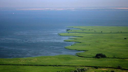
The coast of the Azov Sea is less picturesque and diverse than the Black Sea. But it also has its own, unique beauty. The steppes come close to the sea, and in some places there are floodplains overgrown with reeds. The shores are treeless, sometimes low and flat, with a sandy and shell beach, sometimes low but steep, composed of yellow loess-like loams. The sea coastline forms fairly smooth curves, and only long ones sand spits give it some ruggedness. A large number of spits is one of the characteristic features of the shores of the Azov Sea.
West Coast Sea of Azov
The western coast of the Sea of Azov is represented by a long spit - the Arabat Spit. It stretches along the sea coast for 112 km, separating the shallow Sivash Bay from it. The width of this flat sand-shell spit ranges from 270 m in its southern and middle parts to 7 km in the northern, where there are several small hills. The Arabat Spit is a huge natural beach. A series of long shallows stretched parallel to it. They are clearly visible from the walls of the old Genoese fortress, located near the village of Arabat, or directly from the elevated indigenous bank. In calm, sunny weather, the greenish-blue waves of the sea with a slight noise gently roll onto the sand and shell beach and the foam of the light surf borders it like a narrow white lace. Heeling on the wing, white-winged gulls glide low over the water. In the distance, on the spit, the salt extracted from Sivash shines dazzlingly under the rays of the hot sun. The Sea of Azov is beautiful even in a storm. When a fierce northeast blows, it darkens and becomes harsh. With an angry noise, boiling with white foam, steep waves crash onto the shores. You can spend hours admiring the foamy expanse of the sea, the rapid running and stormy surf of the waves of the Azov Sea.
Any person who has visited the Sea of Azov will forever have memories of its discreet but soul-stirring beauty. On Arabat Strelka open hot mineral water, in its chemical composition and medicinal properties superior to Matsesta ones. Based on these healing waters it is intended to create new resort- Azov Matsesta.
South coast Sea of Azov
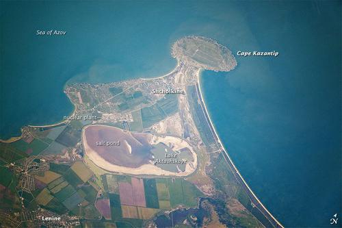
It is represented by the territory of the Kerch and Taman peninsulas, between which is the Kerch Strait, connecting the Azov and Black Sea. The Kerch Peninsula is the eastern tip of Crimea. Its area is about 3 thousand square meters. kilometers. In the depths of the peninsula, large deposits of iron ore have been discovered, feeding the metallurgy of the Azov region, oil and natural gas. The northern and northeastern parts of the Kerch Peninsula are composed of marls, clays, and limestones; Sandstones of Tertiary age are found in places. The western part of the Kerch Peninsula is flat, the eastern part is hilly. Within the peninsula South coast Most of the Azov Sea ends abruptly into the sea, leaving only a narrow strip of beach. In some places, the steep shores are composed of bryozoan limestones, which steadfastly resist the onslaught of sea waves. Such, for example, is Cape Kazantip, at the base of which lies a bryozoan reef - an atoll. To the west of this cape is the Arabat Bay, to the east is the Kazantip Bay. To the east of Cape Kazantip there is a low-lying alluvial section of the coast. The shores of both bays are composed of soft clayey rocks. South of the Cape Kazantip - Aktashskoe salt Lake. This is a relict lake. It is a remnant of the Kazantip Bay, which once extended far into the land. In the middle of the Kerch Peninsula, the low Parpach ridge stretches from west to east. Between this ridge and the shore of the Sea of Azov there is a wide longitudinal valley. In its lower parts there are salt lakes, and in particular Lake Chokrak, known for its healing properties, as well as a number of mud volcanoes.
To the east of the Kazantip Bay, near the Kerch Strait, the coast of the Azov Sea is calmer, but here it is characterized by capes composed of hard bryozoan limestones, for example, capes Zyuk, Tarkhan and others. The Kerch Strait, connecting the Black and Azov Seas, is shallow and relatively narrow. Its width ranges from 4 to 15 km. The length of the strait is 41 km. The depth is about 4 m. In ancient times, the Kerch Strait was called the Cimmerian Bosporus. The name itself contains a hint of the shallowness of the strait, since “bospor” translated into Russian means “bull ford”. Crimean coast The strait is steep in places. In its northern part lies the port city of Kerch.
The Caucasian coast of the Kerch Strait is low, sandy, with dunes in places. The channel of the strait is cluttered with reefs, sand bars and coastal shoals, which previously made navigation difficult. Now a canal has been dug in the strait for the passage of ships with deep draft. Taman Peninsula, which is part Krasnodar region, covers an area of approximately 1900 sq. km. Of this, land accounts for a little more than 900 square meters. km, and the rest of the territory is estuaries and floodplains.
Its nature is peculiar. From a geological point of view, this is a young peninsula, as it was formed in the Quaternary period. Back in the 1st century AD. e. in its place there were about five islands, the transformation of which into a peninsula occurred, apparently, in the 5th century AD. e. under the influence of the accumulative activity of the Kuban River, mud volcanoes and tectonic uplifts. The formation of the Taman Peninsula continues.
If you need to find a paradise on Azov Sea coast map for holidays It will help you a lot with this. Find out about beautiful villages and tourist cities - your vacation will be what you dreamed of. Choosing a holiday on the Sea of Azov on the map.
Coast of Azov, map for tourists
What is the best way to relax on the coast of the Azov Sea? A holiday map to help tourists.
A seaside holiday always seems like something fabulous, but it can bring a lot of headaches when it comes to questions of “where”, “how long” and “how expensive”. In order not to think about such problems, you need to have information about the region where you want to soak up the sun.
The Azov region from Taganrog and Kuban stretches for 250 km, another 200 km belong to Crimea. This huge area is simply “stuffed” with a large number of resort towns and places for recreation, and there are several reasons for this: the shallow depth of the reservoir allows the sun to warm the water well, hot steppe air reigns around, and the long duration of the swimming season.
In order for your vacation to go well, you need to clearly set the purpose of the trip before leaving. If you are traveling with children, then you should choose a locality with amusement parks and developed medical infrastructure. If you want to take a break from the bustle of the city, then a small village with private houses is an option for you.
Many people go to the sea to treat some health problems. The air here is saturated with salts and some other elements, which helps fight allergies, coastal mud is excellent for problem skin, and iodine-rich water and soil are indicated for people with a diseased thyroid gland.
As you can see, there are a lot of possibilities oncoast of the Sea of Azov and without a map for recreation there's really no way around it. Let's go through the most popular options.
You can also submit a question by filling out this form:
Holidays on the Azov Sea in the private sector If you are one of those people who want to forget about the urban noise and flow of people for just a moment, thenHolidays on the Azov Sea in 2019 private sector: all the nuances
 Remember that such recreation has both its pros and cons. The first ones include:
- lower cost, you do not overpay for the “name” of the hotel and the number of its stars;
- you can choose an absolutely personal option in the most comfortable and quiet place;
- The rest mode is determined only by you;
- you can find a private house in a beautiful “unpromoted” place, where crowds of tourists do not scurry around.
There are also a number of negative aspects of this approach:
- you will have to be responsible for your own life, that is, cook, clean, shop;
- comparing with the same hotels, there are no standards for this type of property, so there is a risk of not finding quality housing;
- if recreation centers and sanatoriums often have private beach, then in the case of private real estate this is very rare.
If the disadvantages do not stop you, then you should look in small villages such as Ilyich, Kuchugury, Priazovsky, Krugloye, the villages of Taman or Golubitskaya. In such settlements there is a fairly large private quarter, and taking into account the fact that they are constantly on the lips of tourists, the owners try to keep the quality bar high in order to subsequently rent out houses for good money.
An additional benefit of searching in these villages is thatholiday on the Sea of Azov in 2019 in the private sector We cannot imagine without normal infrastructure. Therefore, in such popular places among travelers there are shops, cafes, and attractions. There are also plenty of hotels, so if you get tired of your house, you can easily change the location (if, of course, there are free rooms).
If we use “personalities”, then Golubitskaya is suitable for those who want to improve their health, because it houses many sanatoriums. Taman is ideal for those who want silence, the sea and interesting architecture. So, in it you can find the Church of the Intercession, the first in Kuban, the only Turkish wells of its kind in Russia, the Lermontov house-museum, and the Finagorian fortress. The situation is similar with Krugly, near which there are several dozen ancient mounds. As you can see, small villages have a lot to offer even the capricious tourists, especially for intimate family travelers.
Holidays on the coast
Sea of Azov: resort towns
Not everyone likes small villages; others like to feel the festive atmosphere around them. Thankfully it's aroundSea of Azova large number are scatteredresort cities
, where life pulsates all night long. WITHThe most popular is probably Yeysk. It houses a large number of sanatoriums, especially many that deal with respiratory diseases. 
Yeisk
But it is famous not only for its medical institutions: many recreation centers, cinemas, cafes and restaurants. At its core, Yeysk is tourist town With developed infrastructure, which is not inferior to Turkish or Thai competitors. Like most of the best Azov vacation spots, it is located on Taman Peninsula and comes into contact with the warm waters of the Yeisk Gulf, which explains the excellent climatic conditions in the summer in a populated area.
Shchelkino
SCH Yolkino is a town in the Crimean part of the Azov region with a large number of boarding houses and beautiful sandy beach. Its superiority can be considered its location on the Kerch Peninsula, where the waters are always well warmed up and the air is rich in salt.
Primorsko-Akhtarsk
Primorsko-Akhtarsk is also famous for its natural conditions. Firstly, it is located near Khan Lake and several other reservoirs of this type. They are rich in salt, isolated from the sea and very useful if you have breathing problems. Secondly, this city is located between the Taman and Taganrog regions, which is why many people never come here and a quiet atmosphere always prevails.
Azov
Azov and the Pavlo-Ochakovskaya spit located nearby are also quite famous among our fellow citizens. The latter is an alluvial shell-sand natural formation with a large number of well-groomed beaches. There is a highway connecting Azov and Yeysk nearby, so getting here is quite easy, and if you have nowhere to put your car, paid parking is available.
Vecherne coast of the Sea of Azov
Nature and excursions
It is generally accepted that natural beauty is not the strong point of the Azov Sea. The landscapes are dominated by steppes, the vegetation is rather poor, because the hot air leaves little moisture for it. We want to assure you that the situation is not entirely like that. Of course, most resorts located near the beaches, where there is no place for dense forests, but the whole Krasnodar region and Crimea are famous for their beautiful places.
 If you do not belong to the cohort of people who are ready to spend all 10 or 14 days of vacation in only one location, then the Azov region will satisfy your tastes. There is a whole scattering of interesting places:
- Salt Lake, famous for its waters;
- Tuzlinskaya Spit;
- waterfalls in the Dzhegosh gorge;
- St. Barbara's springs;
- many places where wine is made;
- Tiger and Gentle caves.
All of the above objects are located in the Krasnodar region. There are even more of them in Crimea: starting with the mountains and ending with the famous Crimean spits.
If you prefer urban motifs and architecture, then there are options here too. For example, you can visit Krasnodar - administrative center region of the same name, or in the glorious Rostov-on-Don. Crimea is famous for its architecture and cities: Evpatoria, Sevastopol, Yalta, Bakhchisarai. And if you are closer southern regions our homeland, it is easy to get to Sochi from the Azov region and wander along their embankment.
It is not necessary to buy an excursion in advance (although this is encouraged), because on the spot you can find many offers from local travel companies.
Holidays on the Azov coast
Service level
There is a myth that infrastructure and quality services are not about the Russian Azov region. Perhaps years 15 ago this was true, but now local tourist centers and hotels are focused on creating competition for other markets, in particular Turkish companies.
If we take examples, in the city of Yeisk there are two cinemas, many cafes and restaurants, water parks, and an amusement park. You can find both a cheap house and a room in expensive hotel. The beaches near such buildings are additionally controlled; on them you can find sun loungers, umbrellas, and beach cafes. There are patrols and doctors everywhere.
Changes in small settlements did not go unnoticed either. For example, large hotels have also been built in the village of Golubitskaya, and there is a whole scattering of modern sanatoriums.
Reliable assistants
 Choosing a place is, although a pleasant pain, but still a pain. It is sometimes impossible to do this remotely because there are too many factors that are simply difficult to take into account. Understanding all this, we work for your benefit, selecting the best options for you and organizing interesting tours. We are guided by such concepts as safety, interestingness, convenience and are looking for suitable options, taking into account your budget and your personal requirements. In any case, we will find a place that suits you.
In a small village or big city, you will have interesting days oncoast of the Sea of Azov holiday map in memories that will never be forgotten.
Video
The Sea of Azov is a truly unique gift of nature, which we must appreciate. It is unique in its appearance, depth, size, animal composition and flora and plays a very important role in the ecosystem of the region.
Short historical reference. In ancient times, the Sea of Azov did not exist! The full-flowing Don River flowed into the ancient Black Sea (approximately in the area of the modern Kerch Strait).
There is a theory according to which around 5600 BC there was a very strong rise in the water level of the Black Sea, which was caused by a major earthquake. (Perhaps it was this event that gave rise to the legends of the Flood).
Sea of Azov - Origin of the name. This area has always been at the intersection of the historical paths of different peoples and therefore managed to change a large number of names. The ancient Greeks who lived on these shores affectionately called it Maeotis (Nurse - translated from Greek). The ancient Romans jokingly called it Palus Maeotis (Meotian swamp) due to its shallow waters. The Scythians nicknamed it Kargulak (Sea Rich in Fish). The Meotian tribes called him Temerinda (meaning Mother of the Sea). The Turks called it Barkh el-Assak (Dark Blue Sea). The Horde conquerors called it Balyk-dengiz (Fish Sea).
The main theory for the appearance of the original name – Azov – comes from the Turkic adjective “azak” (meaning river mouth, low place). Subsequently, the word “azak” was transformed into the modern one - Azov.
The Sea of Azov is an inland sea in the eastern part of Europe. Based on its distance from the world ocean, the Sea of Azov is considered a continental sea. The Sea of Azov is connected to the Atlantic Ocean through a very long chain of seas and straits. (Black Sea, Sea of Marmara, Aegean Sea, Mediterranean Sea).
On the world map it is “indicated by a small blue speck” and is the shallowest sea in the world. The greatest depth of the Azov Sea does not exceed thirteen and a half meters, and average depth no more than seven meters. Rivers such as the Don, Kuban, Mius, Berda, etc. flow into it.
Scientists classify the Sea of Azov as the so-called “flat seas”, shallow water bodies with low shores, the bottom is replete with sand and shell deposits. The seashore is mostly sandy and only in the southern part there are sometimes small hills of volcanic origin. The coast of the Azov Sea is indented by bays. The coastline is a popular resort and recreational area, there are also nature reserves and National parks. An excellent example of a protected area is Priazovsky national park and the Biryuchiy Island spit.
Sand and shell spits extend out into the open sea for many kilometers and are a real decoration Azov coast. The most famous spits of the Azov Sea: Berdyansk Spit, Fedotova Spit, Peresyp Spit, Stepanovskaya Spit, Obitochnaya, Krivaya, Dolgaya, Belosarayskaya. This is where sanatoriums, boarding houses and popular recreation centers are located.

Temperature regime of the Azov Sea.
The water temperature of the Azov Sea is variable, which is quite normal for shallow reservoirs. The minimum temperature is usually recorded in late January or February and is close to freezing. Only near the Kerch Strait the surface water temperature in the Sea of Azov is always positive. The average annual surface temperature is about +11 degrees Celsius.
In summer, a fairly uniform temperature is established on the surface of the Azov Sea. The warmest water is in July and reaches +28 ... +28.5 degrees Celsius. Between March and August, the water temperature drops from the surface to the bottom by about 1 degree. Temperature distributions can change after the first major storm.

Salinity of the Azov Sea
Due to difficult water exchange with the Black Sea and the abundant influx of fresh river water (up to 12% of the water volume), the salinity of the Azov Sea is not uniform. The salinity of water in the northern part in the area of Taganrog Bay and the salinity of water in the area of the Kerch Strait may differ by several ppm. The average salinity remains at 11% and seasonal fluctuations in the salinity of the Azov Sea usually do not exceed 1%.
In winter, the Sea of Azov freezes quite easily due to the lower salinity of the water in the northern part of the water area from December to March. South part It freezes quite rarely, and the ice is carried into the Black Sea through the Kerch Strait.
The ionic composition of water is quite different from the salt composition of the ocean and has a different set of sodium and chlorine ions. At the same time, there is an increased content of carbonates, sulfates and calcium.
Water transparency in the Sea of Azov
It should be noted that the water transparency of the Azov Sea is rather low. Moreover, water transparency is uneven at different times of the year and ranges from 0.5 to 8 meters. The color of water in the Sea of Azov can also vary from greenish-blue to yellowish.
It may even seem quite “dirty” to uninitiated people. Actually this is not true. Transparency is affected by the abundant flow of river water, the presence of plankton in sea water and the rapid stirring of bottom silts during storm winds. In late autumn and winter, the water of the Azov Sea is more turbid. In the summer, transparency improves significantly, with the exception of the “sea bloom” period, when many plant microorganisms develop in the upper layers of water. Best time for holidays on the Sea of Azov June, July and early August.
Relief of the bottom of the Azov Sea.
The bottom of the Azov Sea has a fairly uniform topography. The depth of the bottom increases smoothly, there are practically no holes or significant differences in depth. Moreover, near the shore there are often small “ripples-paddling pools” in which children love to frolic. This is not surprising, there is usually shallow depth and even warmer water. It is this feature that parents who have small children really like. After all, on the one hand, you don’t have to be afraid that kids will go too deep, and on the other hand, a comfortable depth for swimming adults begins already 15-20 meters from the shore. In the northern part of the water area there is shallow water (20 kilometers with depths of no more than 6 meters). The maximum depth of the Azov Sea is 13.5 meters.
Ecology of the Azov Sea.
Environmentalists have recorded quite strong pollution of coastal waters near large industrial cities on the coast. Thus, the most polluted area of the Azov Sea is the area in the area of Taganrog and Mariupol. At the same time, the section from Berdyansk to Genichesk is environmentally friendly, since it does not have large settlements or industrial enterprises. Sea water should not be drunk (during bathing) or used for gargling by small children. This can cause intestinal upset and fever.
The true pearl of the Azov Sea coast is, which has an exclusively recreational and resort destination and access to the Dairy Estuary. On the other side of the Molochny Estuary, the Azov National Park begins and a small village is located.
Currents in the Sea of Azov.
Currents are often influenced by blowing winds and current directions change quite frequently. The southeast and northeast winds exert their strongest influence. Most often, circular currents are recorded along the seashores (counterclockwise).
Flora and Fauna of the Azov Sea
It is difficult to find a more diverse inland sea in the world in terms of the number of animal and plant organisms. In terms of productivity, the Azov Sea is 160 times greater than the Mediterranean Sea, forty times greater than the Black Sea and six times greater than the Caspian Sea. This is truly an amazing property, considering that the area of the Black Sea is ten times larger than the area of the Sea of Azov!

Phytoplankton and benthos abound in the waters of the Azov Sea. Mollusks occupy a dominant place and their remains are what form bottom sediment.
The ichthyofauna is represented by 103 species of fish (both marine and freshwater). Migratory fish species stay in the sea until they reach sexual maturity, and only enter rivers or estuaries to spawn. The breeding period in most cases does not exceed 2 months. Among the migratory fish in the Sea of Azov, the most valued are: Beluga, Sturgeon, Severyuga, Herring.

Semi-anadromous fish species enter rivers to breed, but they can remain there much longer than anadromous fish species. Sometimes they can remain in rivers for up to one year, and young animals in most cases remain in rivers for winter period time. The most popular semi-anadromous fish species in the Sea of Azov: Taran, Sudak, Bream, Chekhon.
 Goby
Goby
Marine fish species (constantly remaining in sea water) are divided into those permanently living in the Sea of Azov and those coming from the Black Sea. We include the following permanently inhabiting fish species: All types of gobies, pelengas, flounder, turbot, sprat, needlefish, glossa. We include the group of fish entering the Sea of Azov: Azov and Black Sea anchovy, Black Sea herring, red mullet, mullet, Black Sea kalkan, mackerel, horse mackerel, sharpnose, etc.

Freshwater fish constantly live in one area of the reservoir, without moving over significant distances. These types of fish inhabit the coastal waters of the sea containing minimal salinity. These include silver crucian carp, pike, ide, sterlet, and bleak.
Sea of Azov. Minerals.
The depths of the Sea of Azov are replete with minerals. Geologists have discovered zircon, rutile and ilmenite here. Under the bottom of the Azov Sea, if you search well, you can find almost half of the entire periodic table. Significant reserves of natural gas were found in the depths.

The main thing for residents of the Azov Sea coast is to preserve this priceless gift of nature and pass it on to future generations.
The Sea of Azov on the map is a semi-enclosed area of the Atlantic Ocean. The facility is located in the eastern part of Europe. Two countries have the Sea of Azov on their territory - Ukraine and the Russian Federation.
general information
The Sea of Azov is considered the shallowest in the world. His maximum depth- no more than thirteen and a half meters, and the average (according to various estimates) - within 6.8-8 m. In the area where the Sea of Azov is located, there are other objects connecting the water area with the Atlantic Ocean. Among them, the Kerch and Gibraltar straits, the Bosphorus and the Dardanelles should be noted. In addition, the connecting links are the Mediterranean, Aegean and Black Seas.
Story
Previously, in ancient times, where the Sea of Azov is now, there was no water. The filling of the water area supposedly began in 5600 BC. e. At that time, it flowed directly into the Black Sea in the area of the current Kerch Strait. In the area where the Sea of Azov is located, there are different settlements. The names of many of them came from the name of the reservoir. For example, the villages of Priazovskaya and Azovskaya, the city of Azov, which is located in the lower reaches of the river. Don, Novoazovsk and others.
Name
In ancient times, different nationalities called the water area differently. It should be said that the sea was renamed quite a few times. To this day, the exact origin of the name has not been established. There are several hypotheses on the etymology of the original word “Azov”:
- named after Prince Azum, killed in 1067;
- by the name of the tribe “Assy”, which, in turn, presumably came from Avestan and means “fast”;
- in Circassian “uzev”, which means “neck”;
- according to the Turkic word "azan" - "lower".
Back in the distant 1st century. n. e. In his writings, Pliny, listing the Scythian tribes, speaks of the settlement of "Asoks". The name is similar to the word "Azov". It is believed that the modern name of the water area began to be used in Russian toponymy from the beginning of the 17th century, thanks to the chronicler Pimen. At the same time, it must be said that initially not the entire Sea of Azov received the name (on the map of Russia, not far from the part that received the name, the city of Taganrog is located today). And only by the 2nd half of the 18th century the name was assigned to the entire water area.

Research
The history of studying the region where the Sea of Azov is located is conventionally divided into several stages.
- Geographical (ancient), lasting from the time of Herodotus until the early 19th century.
- Geological-geographical. It lasted from the 19th century until the 40s of the 20th century.
- Complex. This period began in the mid-20th century and continues to this day.
Claudius Ptolemy compiled the first map. Ukraine as such did not exist then, and the position of the reservoir itself relative to other objects was not entirely clear. Ptolemy established the first geographical coordinates for cities, bays and capes. Subsequently, Gleb Svyatoslavovich, who ruled in Tmutarakan in 1068, measured the distance from Kerch to Taman using ice. At that time it was approximately 20 kilometers. Already from the 12-14th centuries, the Venetians and Genoese began to draw up maps and sailing directions of the Azov and Black Seas.
Geographical position
The area where the Sea of Azov is located lies between 45°12′30″ and 47°17′30″ N. w. and 33°38′ and 39°18′ E. d. The maximum length of the reservoir reaches 380 kilometers, and its width is 200 kilometers. The coastline has a length of 2686 km, the surface of the water area covers an area of 37,800 square meters. km (this figure does not include spits and islands, which are distributed over an area of 107.9 sq. km). In accordance with its morphological characteristics, the object is classified as a flat sea. The reservoir is considered shallow, with low bank slopes. The Sea of Azov (this is clearly visible on the map of Russia) is quite far from the ocean. In this regard, the object belongs to the group of continental reservoirs. In winter, the Sea of Azov can completely or partially freeze. The ice is carried along the Kerch Strait. Ice formation usually begins in January. In cold years, it can happen a month earlier.

Bathymetry
The place where the Sea of Azov is located has a relatively simple underwater terrain. As you move away from the shore, there is a smooth and slow increase in depth. In the central part of the water area they reach 13 meters. Here the depths are maximum. The location of the isobaths, close to symmetrical, is disrupted by their slight elongation towards the northeast towards the Taganrog Bay. Approximately two kilometers from the coast there is an isobath of 5 meters. It moves away from and near the mouth of the Don River. In this area, the depths increase towards the open part of the reservoir. At the border of the sea and the bay they reach eight to nine meters. The bottom topography is distinguished by the presence of systems of underwater hills. They are stretched along the western (Arabatskaya and Morskaya banks) and eastern (Zhelezinskaya bank) coasts. The depths above them decrease from 8-9 to three to five meters. The coastal underwater slope on the northern coast is characterized by fairly wide shallow waters. The depth here is 6-7 m. The southern coast has a steep underwater slope. The depths in this area are 11-13 meters. Seashores are usually sandy and flat. In the southern section, however, one can find hills that are of volcanic origin, and in some places turn into advanced steep mountains.
The catchment area of the basin is about 586,000 square meters. km. Currents depend on strong winds blowing from the northeast and southwest directions. The main movement occurs along the banks. Its direction is reverse clockwise.

Temperature
Shallow bodies of water are characterized by high seasonal temperature variability. In winter, indicators reach a minimum. In January-February the values are close to freezing temperatures. In the southern part of the reservoir, not far from the Kerch Strait, the thermometer rises above zero. Temperature range per year is +27.5…+28.5 degrees. In summer, fairly uniform indicators are observed across the entire surface of the sea - from +24 to +26 degrees. In July, in some areas (for example, such as the sea, the sea warms up to a maximum of +28... +28.5 degrees. The highest temperature was recorded in Primorsko-Akhtarsk. It was +32.5 degrees. As for the long-term average annual temperature, then on the surface it is within 11 °C. Interannual fluctuations are of the order of one degree.
Salinity
The Sea of Azov has hydrochemical features. They are formed mainly under the influence of abundant river inflow (about 12% of the total water volume). In addition, there is somewhat difficult water exchange with the Black Sea. Before the Don was regulated, the salinity of the reservoir in question was lower than that of the ocean. three times. The indicators varied from 1 ppm at the mouth of the river to 10.5 in the central part and to 11.5 in the Kerch Strait area. began to increase after the construction of the Tsimlyansky hydroelectric complex. By 1977, averages had risen to 13.8 ppm, but the numbers were slightly lower - 11.2. During periods of relatively high humidity, a rapid decrease in salinity was observed. It was 10.9 ‰ at that time. However, by 2000, the figures increased again, stabilizing at 11 ‰. It should be said that in the northern part of the reservoir there is little salt, in contrast to the area to which Crimea adjoins. The Sea of Azov (a map showing the location of the site is presented below) in this area is rich in self-sedimented salt. It has been mined since ancient times. Until the end of the 19th century, salt from this site provided almost half of Russia's needs. The salinity of water reaches its greatest value in the solution - the Sivash brine and other lakes. This is due to intense evaporation from the surface of the water in the summer. All of these hypersaline areas represent large renewable mineral salt deposits for which the Sea of Azov is known. Russia, having these facilities, provides itself with a significant amount of this mineral. Due to the connection with the sea, the composition of their brine is similar to the structure sea water. Mostly brine contains sulfates and chlorides of magnesium and sodium.

Water
The Sea of Azov is characterized by low transparency. It is different in each season and in different areas. Indicators range from 0.5 to 8 meters. Low transparency is mainly due to the influx of large amounts of turbid river water, the fairly rapid stirring up of bottom silts during waves of water, as well as the presence of planktonic masses in the reservoir. The lowest rates are observed in the Taganrog Bay. There, transparency is in the range of 0.5-0.9, in rare cases - 2 meters. The water in this area can vary in color from greenish-yellow to brownish-yellow. In the central part of the reservoir, due to great depths and under the influence of Black Sea currents, transparency can range from one and a half to two and a half to eight meters. Here the water has a greenish-blue color. Almost everywhere in the summer there is an increase in transparency. And in some areas, due to the rather rapid development of tiny animals and plant organisms in the upper layers, the indicators drop to zero. And the water becomes bright green. This phenomenon is called "sea bloom".